


Basics
- Location:
- About 10 miles north of Moab along Hwy. 128
- Suitability:
- Raft,
Canoe - River Length
- 17 miles
- Time:
- 1/2 to 1 day
- Season:
- Year round
Description
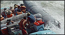
This section of the river is similar to the "Take-Out Beach to Hwy 191" section, but it is less popular so you'll likely have the river more to yourself. Scenery is impressive high canyon walls. The shoreline over this stretch, however, tends to be less sandy and provides fewer opportunities to de-boat, so your picnicking and camping options are limited. This trip can be shortened to 10 miles by taking out at Gold Bar.
Tour Companies
Colorado River & Trail Expeditions
- Grand Canyon & Utah Canyon Country
- Rafting
- 800-253-7328
 Since 1971, Colorado River & Trail Expeditions has offered exceptional
 Helpful Links
Tour Companies
Colorado River & Trail Expeditions
- Grand Canyon & Utah Canyon Country
- Rafting
- 800-253-7328
River Details
Setting:
Desert
Suitability:
Raft
Canoe
Canoe
River Length
17 miles
Time
1/2 to 1 day
Season:
Year round
Guides Available?
Yes
Camping Info
Limited


