


Contact Info
Basics
- Location:
- Arches National Park, near Moab
- Length:
- 7.6 miles (loop)
- Difficulty:
- Easy
- Time:
- 4 1/4 hours
- Elevation Change:
- 280 feet
- Season:
- Year round
Description
| Latest News | |||
Wall Arch Collapses
Wall Arch, located along the popular Devils Garden Trail at Arches National Park collapsed sometime during the night of August 4, 2008. Rock has continued to fall from the arms of the remaining portion of the arch necessitating the closure of the Devils Garden Trail just beyond Landscape Arch. Rock debris has completely blocked this section of the trail. The closure will remain in effect until visitor safety issues can be resolved.
Details
Location:
Length:
Difficulty:
Time:
Elevation Change:
Season:
Additional Details:
Continuing northward on the main trail for another 0.6 mile will bring you to another junction. You will be returning on the path to the right, so for now bear left toward Landscape Arch. Soon you will see a short loop trail on the left leading to this well known landmark.
For most people, Landscape Arch is the high point of the Devils Garden hike. The arch is so improbably long and slender its span seems to defy the laws of physics. The slender ribbon of stone extends for some 300 feet from base to base, and rises 105 feet above the sandy desert floor. Landscape is a very old arch, definitely in the last stages of its existence, but how much longer will it endure? Maybe another century, maybe several, but certainly not more that a thousand years. Because of its size it is difficult to photograph Landscape Arch. But if you want to try plan to be there in the morning, and make sure you bring along a wide angle lens.
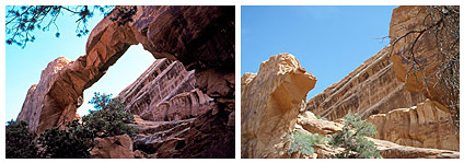
From Landscape Arch the trail continues northward, past Wall Arch, to another short spur trail leading to Navajo and Partition Arches. Navajo Arch, on the western edge of Devils Garden, is the larger of the two. Visiting these two arches will add about 0.7 mile onto your hike.
The main trail ends at Double O Arch, 2.2 miles from the trailhead. From here another short trail on the left goes to the base of the Dark Angel. Dark Angel is a sandstone monolith, about 150 feet high, that stands prominently on the edge of a long narrow bench overlooking Salt Valley. It commands a nice view across the valley of the Klondike Bluffs, on the western edge of the national park. The round trip to Dark Angel will add another 1.0 mile to your hike.
When you are ready to return, you should turn north from Double O Arch, and take the loop trail that goes back through Fin Canyon. This trail is what the Park Service calls a “primitive trail”. It is not as well developed as the main Devils Garden Trail, but it is quite easy to follow and, in my opinion, it is the most interesting part of the hike. The trail wonders through an intriguing collection of thin stone fins, all aligned in a northwest-southeast direction. The fins were formed millions of years ago when the ground rose beneath a solid block of sandstone, causing it to fracture and separate into long, parallel vertical sheets. The existence of these large fins is the primary reason why so many arches have been formed in Arches National Park.
After spending about a mile in Fin Canyon, the trail breaks out on the eastern side of Devils Garden and eventually meets the main trail again just east of Landscape Arch. From the junction it is an easy 0.9 mile walk back the trailhead.


