


Canyonlands National Park is wild, remote, inhospitable, and terribly beautiful. It is home to an immense expanse of deep orange-red canyons and a wonderful array of superlative red rock formations. Canyonlands National Park is recognized as having three separate districts, each with its own feel. Take a moment to read through the information below and become better oriented with the layout of the park and where to go when you get there.
- Park Layout
- Islands in the Sky District
- Needles District
- The Maze District
- Some Other Things To Know
Park Layout
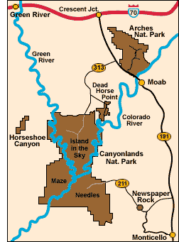 The park is effectively split into three distinct "districts" by the Colorado and Green rivers. Since there are no bridges across the rivers in the park, one must drive great distances to visit more than one area. Canyonlands should therefore be thought of as three distinct parks. Each offers the visitor something a bit different.
The Island in the Sky District sits on a peninsula 1,200 feet above the Colorado and Green Rivers with superb views over the incredible expanse of canyons carved by the two rivers. The entrance to the district is 32 miles southwest of Moab and it is the most accessible and popular section of the park.
Though the Needles District has views of the vast canyons that are the attraction of the Island in the Sky District, the Needles is primarily known for the wonderful red sandstone pinnacles from which it derives its name. It is also home to many other intriguing red rock formations and remarkable terrain. The entrance to the Needles District is located 75 miles southwest of Moab and 45 miles northwest of Monticello
One geologist has called the Maze District a "30 square mile puzzle in sandstone." The "puzzle" is an incredible series of finger like canyons that provide great hiking opportunities for the adventurous (and proficient). The infrequently visited Maze District is near nothing and is accessible only on foot or by 4wd vehicle.
Islands in the Sky District
Layout
The Island in the Sky District occupies a peninsula between the great canyons carved by the Colorado and Green Rivers. Atop the peninsula is the park's main scenic drive. It leads to some short hikes and several overlooks with great views of the the vast orange-red canyons below. This is the most easily visited part of the district.
The top of the peninsula falls away steeply 1,500 feet to a flat desert mesa high above the rivers. Running along the mesa is the famous White Rim 4wd Road, popular with mountain bikers and 4wders. Several trails and two jeep roads run down from the top of the peninsual to this mesa affording great backcountry opportunities.
Scenic Drive and Overlooks
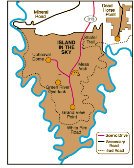 The main scenic drive is 25 miles long, including all branches. In one day, you can easily see the sights, stop for a picnic lunch and also visit Dead Horse Point State Park near the district's entrance. Shafer Canyon Overlook provides a nice view east over the Colorado River. Mesa Arch is a good sized arch clinging to the edge of the canyon rim. The Green River Overlook provides superb views of the Green River and the canyons created thereby. Upheaval Dome consists of a crater about 3 miles across and 1,200 feet deep containing a raised jumble of rock. The Grand View Point Overlook provides the most impressive view in the entire park, and one of the best views in the state.
Backcountry Hiking
Some of the hikes down from the Island in the Sky mesa can be made as day hikes though you must be prepared to climb up out at the end of the day. That's easier said than done, especially when it's hot. Most are better done as backpacking overnighters. As a rule, these trails are steep, rugged and demanding.
Grays Pasture runs through flat grasslands of Gray Pasture for two miles before dropping down over ledges to the White Rim mesa. Gooseberry Canyon is the shortest trail down to the White Rim Road, but it is very steep. Hogback Trail (a.k.a. Murphy Trail) follows a wash then plunges over the mesa rim steeply down to the desert basin of the White Rim mesa. Holeman Spring Trail (a.k.a. Wilhite Trail) is probably the most difficult trail in the Island in the Sky District. Upheaval Dome Trail loops around both sides of Upheaval Dome (a crater about 3 miles across and 1,200 feet deep containing a raised jumble of rock) and then follows Upheaval Canyon to the Green River. Taylor Canyon Trail is the most gradual descent from the Island in the Sky peninsula.
White Rim Road
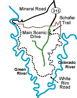 Since bikes are not allowed off-road in Canyonlands, your biking and 4wd options are the same. The primary 4wd route in the district is the White Rim Road. Shafer Trail Road and Mineral Road provide access from the main scenic drive atop the Island in the Sky mesa down to the White Rim Road. Shafer Trail Road is a wonderfully steep switchbacked fall down a cliff wall. It is fun in a 4wd vehicle and challenging on mountain bike. The Mineral Road also involves a steep switchbacked drop, but it is easier and can be driven in a high clearance 2wd vehicle in good weather.The three roads combined form a popular multi-day loop trip for mountain bikers and 4wders.
Needles District
Layout
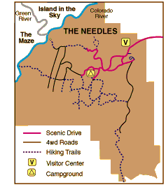 The Needles District of Canyonlands contains fantastic red rock formations and scenery. It is most noted for the many rounded sandstone spires -- "needles" -- that rise hundreds of feet above flat bottomed valleys. Along the districts northwestern border are views of the confluence of the Colorado and Green Rivers and the massive canyons carved thereby. Unlike the Island in the Sky District where you can observe much of its beauty from vantage points along the main scenic drive, you need to hike, bike or 4wd into the Needles' backcountry to adequately experience its treasures.
Scenic Drive
The scenic drive through the Needles District travels through pretty and varied red rock terrain. The drive is about 12 miles long with all branches. Most of it is paved except for a recommended 2 mile spur to Elephant Hill. There are a few picnic areas along the way as well as a few short hikes/nature walks: The Roadside Ruin Trail, the Cave Spring Trail, the Pothole Point Trail, and the Slickrock Foot Trail.
Hiking, Biking and Off-Road
There are numerous good day hikes and backpacking trips available in the Needles backcountry. Trails can be combined in lots of different ways to create loops and to turn day trips into overnighters.
The Maze District
Layout
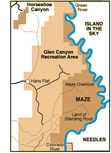 The infrequently visited Maze District is an extraordinarily wild and inhospitable area of great beauty. It features remarkably convoluted slickrock canyons and wonderful red rock formations. Exploring the Maze requires navigating rugged and often difficult 4wd roads (unless, of course, you hike in). Much of the best hiking is among confusing and difficult, though fascinating, finger like canyons. There are no services or supplies anywhere near the Maze, which remains one of the wildest and most pristine areas in the lower 48. It is for the experienced, prepared and adventurous.
The Hans Flat Ranger Station in the Glen Canyon NRA is the de facto entrance station to the Maze district. It sits on a 6,400' peninsula that offers some great panoramas of Canyonlands. The most expansive views are to be had from Panorama Point 10 miles past the ranger station. You might also want to take a spur road near Panorama Point to Cleopatra's Chair, a huge sandstone monolith. North Canyon Trail and Golden Stairs Trail are the two established hiking trails in this area.
The Maze Overlook area contains the remarkably sinuous canyons that give the Maze its name. The hiking in this area is for the experienced only.
The Land of Standing Rocks offers some of the best scenery in the district. There are numerous interesting named rock formations as well as some nice canyon views. At the end of the Land of Standing Rocks Road is the Doll House, so named for its cluster of rounded rock spires. Getting to this area by 4wd vehicle involves some difficult and very slow driving. Six scenic camping areas are available for vehicle camping. A set of trails are accessible from near the Doll House area: Spanish Bottom Trail, Surprise Valley Overlook Trail, and Green River Overlook.
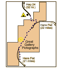 Horseshoe Canyon is a separate unit of Canyonlands situated 20 miles north of Hans Flat Ranger Station. A spring fed creek within the canyon provides nourishment to flowers, grasses, sage and cottonwoods creating a bit of a sanctuary within the arid surrounding desert. The main attraction of this pretty canyon, however, is the Great Gallery -- a collection of life size pictographs created by an archaic Indian culture that existed from 8000 B.C. to 450 A.D. These pictographs may be the most impressive such collection in the country. The Horseshoe Canyon Unit is accessible from Hans Flat from the south or on 2wd dirt roads from the northwest. The road from Hans Flat is rough but navigable by high clearance 2wd vehicles in dry weather. Most persons coming from Hans Flat drive to the canyons northeastern corner and descend on a steep difficult 4wd road into the canyon. The road ends along the canyon floor and a hiking trail leads another 1-1/2 miles to the Great Gallery. A less used and more difficult route from Hans Flat approaches the canyon's southern rim. A hiking trail there descends 600 feet (1-1/2 miles oneway) to the Great Gallery.
Other Things to Know
Overnight camping in the Maze District proper requires a permit ($15 - $30). Person's with vehicles (including bikes) must camp at one of the designated vehicle sites. Call 435-259-4351 for information.
Some Other Things To Know
Pets
Activities with pets are very limited at Canyonlands. Pets are not allowed on hiking trails or anywhere in the backcountry. Pets may not accompany groups traveling by four-wheel-drive vehicle, mountain bike or boat.
Pets may accompany visitors in the developed campgrounds, and may be walked in the park along paved roads. Pets may also accompany visitors traversing the Potash/Shafer Canyon road between Moab and the Island in the Sky. Pets must be leashed at all times when outside a vehicle.


