


Captial Reef National Park has three areas within the park to enjoy a scenic drive. Look through the information below and gain a better orientation of the layout of the park to ensure a great visit.
- Overview
- The Main Scenic Drive
- Highway 24
- Cathedral Valley
- Notum/Bullfrog Road
- Some Other Things To Know
Overview
The best scenery in Capitol Reef is to be found along the park's main scenic drive and along Hwy 24 through the reef. The Cathedral Valley area north of Hwy 24 has some wonderful scenery but is difficult to access. The east side of the reef, reached on rough Notum-Bullfrog Road, is less visited. Each area is introduced below.
The Main Scenic Drive
| |
Fremont Gorge Overlook Trail crosses a mesa then climbs steeply to a lookout 1,000 feet above the Fremont River. Fremont River Trail runs along orchards adjacent to the Fremont River and then climbs Miners Mountain to a good viewpoint of the reef. The Cohab Canyon Trail climbs steeply over switchbacks then more gradually to a hidden canyon above the campground. Frying Pan Trail begins at mile 1.1 of Cohab Canyon Trail and follows the ridge of the Capitol Reef escarpment before joining Cassiday Arch Trail about 3/4 of a mile from the arch. Cassiday Arch Trail climbs steeply up the northern face of Grand Wash Canyon and then heads across slickrock to a vantage point near Cassiday Arch. Grand Wash Trail travels along a narrow wash bottom beneath 800 foot sheer canyon walls. Golden Throne Trail climbs steadily out of Capitol Gorge to great views of the reef and Golden Throne, a massive sandstone monolith. |
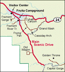 The park's paved Scenic Drive takes you past the visitor center, campgrounds and a very pleasant picnic area to trails and viewpoints along the west side of the reef. You should plan on spending at least a day stopping at the sights, taking a few hikes, and maybe having a picnic lunch. A few hikes to consider are listed below. These are described in more detail in the
 Highway 24
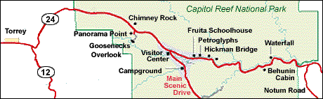
| | Hwy 24 bisects the reef through a canyon carved by the Fremont River. You can make the drive with a few stops in an hour or two, or extend with a few hikes. Hiking trails and other points of interest are briefly described below. (Mileages are from the western park border.)
Chimney Rock Trail climbs switchbacks to good views of Chimney Rock and some nice panoramic views of the park. Panorama Point provides views of the reef to the east and Boulder Mountain to the west. The Goosenecks are several tight hairpin turns carved by the Sulfur River, of which you get a nice perspective from the overlook high above. Sunset Point is at the end of an easy 1/3 mile hike. It offers a terrific panoramic view of the reef with the Henry Mountains in the background, and as it name implies is especially nice at sunset. The one room Fruita Schoolhouse was built in 1896 and closed in 1941. On a cliff face 1/2 mile east of the schoolhouse are numerous Fremont Indian petroglyphs of human figures and mountain sheep. Popular Hickman Bridge Trail climbs to a shaded dry wash that leads to Hickman Bridge, a graceful sandstone bridge that spans 133 feet over the wash. Rim Overlook Trail starts with the Hickman Bridge Trail but then climbs sharply above the dry wash to sheer cliffs 1,000 feet above the park and nearby orchards. Navajo Knobs Trail continues where the Rim Overlook Trail ends and climbs another 500 feet to a great 360 degree panoramic overlook. Fremont River Waterfall is a pleasant, small waterfall on the Fremont River. Cooling off in the pool below the falls is ok, but beware of the strong undertow. It is about 7 miles east of the visitor center. |
Cathedral Valley
The Cathedral Valley area north of Hwy 24 has some wonderful scenery. It is, however, somewhat difficult to access. The area North of Hwy 24, the Northern District, can only be explored by high clearance vehicles, and then only in dry weather. 4wd vehicles are recommended. This is rugged country of desert valleys, fluted cliffs and strikingly bold monoliths. It has a small primitive campground and a few short designated hiking trails.
Notum/Bullfrog Road
Notum Road begins at Hwy 24 just outside of the park's eastern border. It travels south along the eastern side of the reef offering some good views. After 34 miles, it joins the Burr Road and continues south for another 35 miles to Bullfrog Basin Marina on Lake Powell. The road is paved only for about the first five miles. The rest is passable though washboarded and occasionally washed out or sandy.
Muley Twist Canyon is a noted backpacking area accessible from the Notum Road. It is a beautiful deep canyon cut into the waterpocket fold of Capitol Reef, with two main hikes: Upper Muley Twist Canyon, and Lower Muley Twist Canyon.
Some Other Things To Know
Pets
- Pets must be restrained at all times on a leash six feet or less in length. Pets may be walked along the trail from the campground to the visitor center, along roads or in the orchards, but are not permitted on hiking trails.
- Pets may not be left unattended.
- Please clean up after your dog and dispose of waste in the dumpster.


